Home
AC103-6
AC103-7
Accident Reporting
AIM
AeroMedical
Airport Security
Airport Markings
Annual Inspection
ASTM
Board Members
Contact NAPPF
Density Altitude
Endorsements
Flight Parks
Flight
Instruction
Flight
Instruments
Flight Plan
Formation Flying
Hints
History
Home
Insurance
Knowledge Test
LINKS
Light
Sport Aircraft Process
NAPPF UPDATE
Navigation
News
NOTAM
NPRM
Pilot
Privileges & Limitations
Pilot/Instructor Requirements
Part 103
Part 103 Preamble
Radio
Resources
Sectional Charts
Sport
Pilot Topics
TFR
Training
Training Materials
UltraFlight
Magazine
UltraFlight Radio
Visibility & Cloud
Clearance
Visual Approach Slope Indicator (VASI)
Weather
Weather Services
Home
NAPPF
Density Altitude
When it comes to good old-fashioned hangar flying sessions, one subject that almost never seems to be discussed is density altitude. The reason being, too many pilots do not know enough about the subject. Yet, because of the unescapable influence density altitude has on aircraft and engine performance, it is important for every pilot to understand its effects. Hot, high, and humid weather conditions can change a routine takeoff or landing into an accident in less time than it takes to tell about it. There are three important factors that affect air density.
- Altitude. The higher the altitude, the less dense the air.
- Temperature. The warmer the air, the less dense it is.
- Humidity. Humidity is not generally considered a major factor in density altitude computations because the effect of humidity is related to engine power rather than aerodynamic efficiency. At high ambient temperatures, the atmosphere can retain a high water vapor content. For example, at 96 degrees F, the water vapor content of the air can be eight (8) times as great as at 42 degrees F. High density altitude and high humidity do not often go hand-in-hand. However, if high humidity does exist, it would be wise to add 10% to your computed takeoff distance and anticipate a reduced climb rate.
The Pilot's Operating Handbooks prepared by the
Airframe Manufacturers provide good information regarding the aircraft
performance under standard conditions (sea level at 59 degrees F). However, if a
pilot becomes complacent regarding aircraft performance or is careless in using
the charts, density altitude effects may provide an unexpected element of
suspense during takeoff and climb.
Density altitude effects are not confined to mountain areas. They also apply at
elevations near sea level when temperatures go above standard 59 degrees F or 15
degrees C). It's just that the effects are increasingly dramatic at the higher
elevations. Takeoff distance, power available (in normally aspirated engines),
and climb rate are all adversely affected, and while the indicated airspeed
remains the same, the true airspeed increases. Too often, a pilot who is flying
in high density altitude conditions for the first time in an aircraft with a
normally aspirated engine becomes painfully aware of the retarded effect on the
aircraft performance capabilities.
Additionally, at power settings of less than 75%, or at density altitudes above
5,000 feet, it is essential that normally aspirated engines be leaned for
maximum power on takeoff unless equipped with an automatic altitude mixture
control. Otherwise, the excessively rich mixture adds another detriment to
overall performance. Turbocharged engines, on the other hand, need not be leaned
for takeoff in high density altitude conditions because they are capable of
producing manifold pressure equal to or higher than sea level pressure.
Density altitude is not to be confused with pressure altitude, indicated
altitude, true altitude or absolute altitude, and is not to be used as a height
reference, but will be used as determining criteria for the performance
capabilities of the aircraft. The published performance criteria in the Pilot's
Operating Handbook is generally based on standard atmospheric conditions at sea
level (59 degrees F to 15 degrees C and 29.92 inches of mercury).
When the temperature rises above the standard temperature for the locality, the
density of the air in that locality is reduced and the density altitude
increases. This affects the aircraft aerodynamic performance, and decreases the
horsepower Output of the engine. Pilots should; make a practice of checking
their aircraft performance charts during preflight preparation. This is
important when temperatures are above normal regardless of airport elevation.
This chart gives a rule of thumb example of temperature affects on density
altitude.
|
STD TEMP |
ELEV/TEMP |
8O deg. F |
90 deg. F |
1OO deg. F |
11O deg. F |
120 deg. F |
130 deg. F |
|
59 deg F |
Sea Level |
1,200' |
1,900' |
2,500' |
3,200' |
3,800' |
4,400' |
|
52 deg F |
2,000' |
3,800' |
4,400' |
5,000' |
5,600' |
6,200' |
6,800' |
|
45 deg F |
4,000' |
6,300' |
6,900' |
7,500' |
8,100' |
8,700' |
9,400' |
|
38 deg F |
6,000' |
8,600' |
9,200' |
9,800' |
10,400' |
11,000' |
11,600' |
|
31 deg F |
8,000' |
11,100' |
11,700' |
12,300' |
12,800' |
13,300' |
13,800' |
From the pilot's point of view, an increase in density altitude results in:
- Increased takeoff distance.
- Reduced rate of climb.
- Increased true airspeed on approach and landing (same IAS).
- Increased landing roll distance.
At airports of higher elevations, such as those in the Western United States, high temperatures sometimes have such an effect on density altitude that safe operations are impossible. In such conditions, operations between midmorning and mid-afternoon can become extremely hazardous. Even at lower elevations, aircraft performance can become marginal and it may be necessary to reduce aircraft gross weight for safe operations. Therefore, it is advisable, when performance is in question, to schedule operations during the cool hours of the day, early morning or late afternoon, when forecast temperatures are expected to rise above normal. Early morning and late evening are sometimes more ideal for both departure and arrival.
A pilot's first reference for aircraft performance information should be the operational data section of the Aircraft Owner's Manual or the Pilot's Operating Handbook developed by the aircraft manufacturer. When these references are not available, the Koch Chart may be used to figure the approximate temperature and altitude adjustments for aircraft takeoff distance and rate of climb.
The Koch Chart for Altitude and Temperature Effects
To find the effect of altitude and temperature, connect the temperature and airport altitude by a straight line. Read the increase in take-off distance and the decrease in rate of climb from standard sea level values.
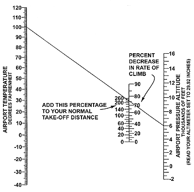
Example:
The diagonal line shows that 230% must be added for a temperature of 100 degrees
and a pressure altitude of 6,000 feet. Therefore, if your standard temperature
sea level take-off distance, in order to climb to 50 feet, normally requires
1,000 feet of runway, it would become 3,300 feet under the conditions shown. In
addition, the rate of climb would be decreased 76%. Also, if your normal sea
level rate of climb is 500 feet per minute, it would become 120 feet per minute.
This chart indicates typical representative values for "personal" airplanes. For
exact values consult your airplane flight manual. The chart may be conservative
for airplanes with supercharged engines. Also remember that long grass, sand,
mud or deep snow can easily double your take-off distance. (END
OF DOCUMENT FAA-P-8740-2 AFS-800-0478)
2/9/04
AVweb February 9, 2004
Need AWOS? Just Call On Your Cellphone
In a nifty new service for pilots, a quick toll-free phone call can now
connect you to any AWOS in the U.S. -- if
you don't mind having to listen to a short advertisement before you get to the
weather. The service, aptly called "anyAWOS,"
is a new product offered by Mackinac Software. One of the co-creators of the
system, Bill McUmber, told AVweb: "Although my company is a software
company, I am an active IFR pilot and thought it would be useful to be able to
check conditions on the fly -- hence this system." After dialing the toll-free
number (877-any-AWOS, or 877-269-2967), callers can enter any three-digit
airport ID and -- after choosing from a list of possible matches, and listening
to a word from their sponsors -- they will be connected to that airport's AWOS
or ATIS. For those times when you have already received a briefing and just want
an update on the current conditions before departure, this is easier than
looking up the AWOS/ATIS phone number. In a news release, the company says the
service allows pilots to easily check actual, right-now weather conditions at
intermediate and destination airports while en route, or anytime -- for example,
checking downstream conditions on the ramp during a gas stop. "We just announced
this yesterday, and we are absolutely amazed that the call volume is ramping up
already," McUmber said on Friday.