Home
AC103-6
AC103-7
Accident Reporting
AIM
AeroMedical
Airport Security
Airport Markings
Annual Inspection
ASTM
Board Members
Contact NAPPF
Density Altitude
Endorsements
Flight Parks
Flight
Instruction
Flight
Instruments
Flight Plan
Formation Flying
Hints
History
Home
Insurance
Knowledge Test
LINKS
Light
Sport Aircraft Process
NAPPF UPDATE
Navigation
News
NOTAM
NPRM
Pilot
Privileges & Limitations
Pilot/Instructor Requirements
Part 103
Part 103 Preamble
Radio
Resources
Sectional Charts
Sport
Pilot Topics
TFR
Training
Training Materials
UltraFlight
Magazine
UltraFlight Radio
Visibility & Cloud
Clearance
Visual Approach Slope Indicator (VASI)
Weather
Weather Services
Home
Hints
Helpful Hints and Bits of Data
TOPICS
Need AWOS? Just Call On Your Cellphone
Air to Air Communication
Airport Watch
DENSITY ALTITUDE
w/sound clip
Photo ID
National Park Flights
Rotax Online Maintenance Manuals
Windsock
Powered
Parachute Winter Activities
2/9/04
AVweb
February 9, 2004
Need AWOS? Just Call On
Your Cellphone
In a nifty new service for pilots, a quick toll-free phone call can now connect you to any AWOS in the U.S. -- if you don't mind having to listen to a short advertisement before you get to the weather. The service, aptly called "anyAWOS," is a new product offered by Mackinac Software. One of the co-creators of the system, Bill McUmber, told AVweb: "Although my company is a software company, I am an active IFR pilot and thought it would be useful to be able to check conditions on the fly -- hence this system." After dialing the toll-free number (877-any-AWOS, or 877-269-2967), callers can enter any three-digit airport ID and -- after choosing from a list of possible matches, and listening to a word from their sponsors -- they will be connected to that airport's AWOS or ATIS. For those times when you have already received a briefing and just want an update on the current conditions before departure, this is easier than looking up the AWOS/ATIS phone number. In a news release, the company says the service allows pilots to easily check actual, right-now weather conditions at intermediate and destination airports while en route, or anytime -- for example, checking downstream conditions on the ramp during a gas stop. "We just announced this yesterday, and we are absolutely amazed that the call volume is ramping up already," McUmber said on Friday.
1/7/04
Powered Parachute Winter Activities
Dear Fellow Powered Parachuters,
I know how frustrating it is to have either cold or wind every time you think
about flying. I share your frustration. However, now is the time to spend time
with your machine and make sure that it is ready to fly safely when the weather
gets nicer. Time you spend now in preventive maintenance may very well keep you
flying some day next spring or summer instead of being down for maintenance and
repairs. Let’s look at what we can do right now!!
I. Now is the time to perform that annual inspection. You as owner of the PPC
can perform this inspection yourself, and it will help you become more familiar
with your unit at the same time. Use the attached form to perform this
inspection. Bring your log book up to date also.
II. Engine Maintenance can be performed now. Use the Rotax maintenance schedule
and see if there is something that is approaching that you can do early. For
instance, you may want to replace spark plugs right now instead of waiting
another 4 hours and having to do it when the weather is warm. Maybe you are
nearly due for a gearbox oil change, and you can do it now instead of this
summer. Remember to run your engine every couple weeks during the winter.
III. Inspect the Airframe thoroughly. Now is a good time to examine the
stitching on the seat belts and shoulder harnesses. Now is a good time to use
some wire ties and make your wiring neater by taking the drooping spots out of
it. Examine every nut and bolt for condition and security. Check tire
pressure. Examine the exhaust system. Consider draining and cleaning the fuel
tank.
IV. Replace all fuel lines now. This is something to be done annually. Go
ahead and do it now. Include replacement of the fuel filter. Remember to
install special pulse line between the engine and the fuel pump. That means
about 9 inches of special tubing to give you better performance – especially for
the air-cooled engines. Make sure this pulse line is properly clamped on each
end also. Many engine failures can be attributed to weak or failing pulse line.
V. Canopy Inspection. If you do not want to do this yourself, call Mojos for
canopies made outside the US. If you have a PD or a Quantum, call them and
arrange for an inspection. This is something you can do yourself if you wish.
Have plenty of space and a clean area with no fuel or oil around. It is best to
be able to hang the canopy up by the tail end so all the stuff comes out of the
cells. You can also clean the stuff out by using a vacuum cleaner. Make sure
the cells are clean. Test the material using the “suck” test. Inspect every
line and every seam and every line connection.
VI. Check your paperwork. You need proof of registration. You need
documentation of the annual inspection you are performing. You need a copy of
your exemption, and if you are not a BFI/UFI, you need a copy of the endorsement
you are operating under.
VII. Check your accessories. Test your radios and helmets and intercoms. Put
your PPC battery on a trickle charger overnight. Inspect your line sock zippers
for wear or damage. Clean out your canopy bag. Tighten the lug nuts on your
trailer, and test the lights on it. Check tire pressure, too.
Let’s get ready to have some fun!!
Thanks,
Ralph McClurg
Also see
Annual Inspection
5/16/03
Windsock
AOPA e-Pilot Volume 5, Issue 20 • May 16, 2003
Question: How do you gauge the wind by looking at the airport windsock? What
does it mean when it's out at a 45-degree angle? When it's pointing straight
out?
Answer: The windsock (or the "wind cone," as it is called by the FAA) is a
good source of information for the pilot. It not only indicates wind direction,
but also allows the pilot to estimate wind velocity and gusts. According to FAA
Advisory Circular 150/5345-27C "Specification for Wind Cone Assemblies" (download
from AOPA Online), a windsock will take the form of a truncated cone when filled
with air. It must move freely and indicate the wind direction within 5 degrees
in a 3-knot wind. The AC also specifies that the cone will be fully extended in
a wind of 15 kt. So, you may estimate that a limp windsock indicates a no-wind
condition. A windsock extended at 45 degrees may indicate a wind of around 7 kt,
and when the windsock is fully extended, the winds may be 15 kt or higher.
Windsocks will tend to move back and forth when the wind is gusty. They point
downwind, so when you land or take off, you will be flying from the smaller end
of the cone toward the larger. For more information on windsocks or other wind
indicators, take a look at
"Wind Cones" and
"Which Way is the Wind Blowing?" from the August 1996 issue of Flight
Training magazine.
12/9/02
National Park Flights
AVflash Vol. 8, Issue 50a Monday, December 9, 2002
NONCOMMERCIAL PARK FLIGHTS OKAY:
Most GA pilots don't have to worry about new flight restrictions that may be
imposed over national parks, according to AOPA. An AOPA news release says the
association was able to convince the FAA that GA overflights don't create much
noise in the parks. And to make sure it stays that way, AOPA is asking that
pilots not be tempted to drop below 2,000 feet agl while overflying the nation's
parks. The new rule will require commercial air-tour operators flying less than
5,000 feet agl above national parks or abutting tribal lands to get a permit
from the FAA.
11/29/03
AOPA AIRPORT WATCH PROGRAM GETS UNDER WAY
AOPA
ePilot
Volume 4, Issue 48 .
November 29, 2002
The toll-free number to report suspicious activity at an airport, 866/GA-SECURE
(866/427-3287), goes live on Monday (December 2). The Transportation Security
Administration (TSA), which is funding and operating the 24-hour hotline, has
partnered with AOPA in providing an easy-to-remember national number as part of
AOPA's Airport Watch program to help protect national security at our nation's
general aviation airports. AOPA also has created posters and pamphlets to show
pilots
examples of suspicious activities, steps pilots can take to help law
enforcement, and sensible precautions for improving airport security. The
brochure is available online and will be mailed to the more than 388,000 AOPA
members next month. See AOPA Online
http://www.aopa.org/whatsnew/newsitems/2002/02-4-114x.html .
11/1/02
PHOTO ID LAW NOW IN EFFECT
AOPA
ePilot
Volume 4, Issue 44 . November 1, 2002
Pilots are reminded that beginning this week, a government-issued photo
identification, in addition to pilot and medical certificates, must be carried
when flying an aircraft. AOPA petitioned for the new requirement in February as
a way to meet the intent of the Aviation and Transportation Security Act, which
requires the Under Secretary of Transportation to consider a photo-ID pilot
certificate. The requirement to carry a government-issued photo ID, such as a
driver's license, is less costly and quicker to implement; it took effect
Monday.
See AOPA Online <http://www.aopa.org/whatsnew/newsitems/2002/02-4-021.html>
for more information.
7/12/03
DENSITY ALTITUDE
Jim Sweeney, NAPPF
Part one of learning how to cope with changes in density altitude. With summer
here, you need to recognize that there are differences in density altitude and
understand how it changes your flying. Jim Sweeney explains it from the
beginning. www.nappf.com/Hints
(6/24/03)
![]()
Jim Sweeney, NAPPF
Part two of learning how to cope with changes in density altitude. Jim Sweeney
covers issues including those operating in high altitudes and carburetion.
www.nappf.com/Hints (6/24/03)
![]()
When it comes to good old-fashioned hangar flying
sessions, one subject that almost never seems to be discussed is density
altitude. The reason being, too many pilots do not know enough about the
subject. Yet, because of the unescapable influence density altitude has on
aircraft and engine performance, it is important for every pilot to understand
its effects. Hot, high, and humid weather conditions can change a routine
takeoff or landing into an accident in less time than it takes to tell about it.
There are three important factors that affect air density.
- Altitude. The higher the altitude, the less dense the air.
- Temperature. The warmer the air, the less dense it is.
- Humidity. Humidity is not generally considered a major factor in density altitude computations because the effect of humidity is related to engine power rather than aerodynamic efficiency. At high ambient temperatures, the atmosphere can retain a high water vapor content. For example, at 96 degrees F, the water vapor content of the air can be eight (8) times as great as at 42 degrees F. High density altitude and high humidity do not often go hand-in-hand. However, if high humidity does exist, it would be wise to add 10% to your computed takeoff distance and anticipate a reduced climb rate.
The Pilot's Operating Handbooks prepared by the
Airframe Manufacturers provide good information regarding the aircraft
performance under standard conditions (sea level at 59 degrees F). However, if a
pilot becomes complacent regarding aircraft performance or is careless in using
the charts, density altitude effects may provide an unexpected element of
suspense during takeoff and climb.
Density altitude effects are not confined to mountain areas. They also apply at
elevations near sea level when temperatures go above standard 59 degrees F or 15
degrees C). It's just that the effects are increasingly dramatic at the higher
elevations. Takeoff distance, power available (in normally aspirated engines),
and climb rate are all adversely affected, and while the indicated airspeed
remains the same, the true airspeed increases. Too often, a pilot who is flying
in high density altitude conditions for the first time in an aircraft with a
normally aspirated engine becomes painfully aware of the retarded effect on the
aircraft performance capabilities.
Additionally, at power settings of less than 75%, or at density altitudes above
5,000 feet, it is essential that normally aspirated engines be leaned for
maximum power on takeoff unless equipped with an automatic altitude mixture
control. Otherwise, the excessively rich mixture adds another detriment to
overall performance. Turbocharged engines, on the other hand, need not be leaned
for takeoff in high density altitude conditions because they are capable of
producing manifold pressure equal to or higher than sea level pressure.
Density altitude is not to be confused with pressure altitude, indicated
altitude, true altitude or absolute altitude, and is not to be used as a height
reference, but will be used as determining criteria for the performance
capabilities of the aircraft. The published performance criteria in the Pilot's
Operating Handbook is generally based on standard atmospheric conditions at sea
level (59 degrees F to 15 degrees C and 29.92 inches of mercury).
When the temperature rises above the standard temperature for the locality, the
density of the air in that locality is reduced and the density altitude
increases. This affects the aircraft aerodynamic performance, and decreases the
horsepower Output of the engine. Pilots should; make a practice of checking
their aircraft performance charts during preflight preparation. This is
important when temperatures are above normal regardless of airport elevation.
This chart gives a rule of thumb example of temperature affects on density
altitude.
|
STD TEMP |
ELEV/TEMP |
8O deg. F |
90 deg. F |
1OO deg. F |
11O deg. F |
120 deg. F |
130 deg. F |
|
59 deg F |
Sea Level |
1,200' |
1,900' |
2,500' |
3,200' |
3,800' |
4,400' |
|
52 deg F |
2,000' |
3,800' |
4,400' |
5,000' |
5,600' |
6,200' |
6,800' |
|
45 deg F |
4,000' |
6,300' |
6,900' |
7,500' |
8,100' |
8,700' |
9,400' |
|
38 deg F |
6,000' |
8,600' |
9,200' |
9,800' |
10,400' |
11,000' |
11,600' |
|
31 deg F |
8,000' |
11,100' |
11,700' |
12,300' |
12,800' |
13,300' |
13,800' |
From the pilot's point of view, an increase in density altitude results in:
- Increased takeoff distance.
- Reduced rate of climb.
- Increased true airspeed on approach and landing (same IAS).
- Increased landing roll distance.
At airports of higher elevations, such as those in the Western United States, high temperatures sometimes have such an effect on density altitude that safe operations are impossible. In such conditions, operations between midmorning and mid-afternoon can become extremely hazardous. Even at lower elevations, aircraft performance can become marginal and it may be necessary to reduce aircraft gross weight for safe operations. Therefore, it is advisable, when performance is in question, to schedule operations during the cool hours of the day, early morning or late afternoon, when forecast temperatures are expected to rise above normal. Early morning and late evening are sometimes more ideal for both departure and arrival.
A pilot's first reference for aircraft performance information should be the operational data section of the Aircraft Owner's Manual or the Pilot's Operating Handbook developed by the aircraft manufacturer. When these references are not available, the Koch Chart may be used to figure the approximate temperature and altitude adjustments for aircraft takeoff distance and rate of climb.
The Koch Chart for Altitude and Temperature Effects
To find the effect of altitude and temperature, connect the temperature and airport altitude by a straight line. Read the increase in take-off distance and the decrease in rate of climb from standard sea level values.
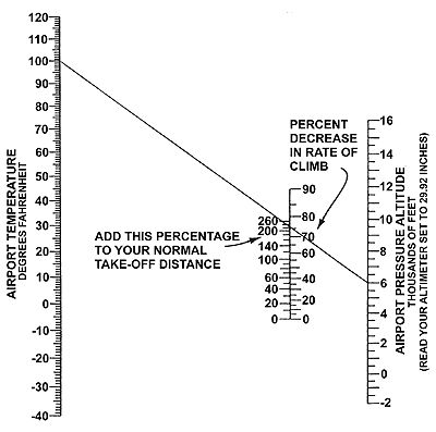
Example:
The diagonal line shows that 230% must be added for a temperature of 100 degrees
and a pressure altitude of 6,000 feet. Therefore, if your standard temperature
sea level take-off distance, in order to climb to 50 feet, normally requires
1,000 feet of runway, it would become 3,300 feet under the conditions shown. In
addition, the rate of climb would be decreased 76%. Also, if your normal sea
level rate of climb is 500 feet per minute, it would become 120 feet per minute.
This chart indicates typical representative values for "personal" airplanes. For
exact values consult your airplane flight manual. The chart may be conservative
for airplanes with supercharged engines. Also remember that long grass, sand,
mud or deep snow can easily double your take-off distance.
(END
OF DOCUMENT FAA-P-8740-2 AFS-800-0478)
5/14/02
The Aero-News Network Daily
News Brief
www.Aero-News.Net
Rotax: No Failure to Communicate
Newest Moves Make Everybody
More Enlightened
 Eric
Tucker, Rotax guru and ANN columnist, has let us know that Rotax has made some
recent decisions that will change owners' habits. Lots of mechanics get familiar
with a particular engine, and work from their memory, evermore. While that
usually works, it's not foolproof. Materials and procedures change over time,
and things like clearances and torque values change along with them. It's easy
to do damage, over torquing a nut, just as it is a bad idea to under torque one.
When the stud material changes, or the thread design is upgraded, torque values
typically are adjusted accordingly. The value in the mechanic's head, though,
doesn't get upgraded.
Eric
Tucker, Rotax guru and ANN columnist, has let us know that Rotax has made some
recent decisions that will change owners' habits. Lots of mechanics get familiar
with a particular engine, and work from their memory, evermore. While that
usually works, it's not foolproof. Materials and procedures change over time,
and things like clearances and torque values change along with them. It's easy
to do damage, over torquing a nut, just as it is a bad idea to under torque one.
When the stud material changes, or the thread design is upgraded, torque values
typically are adjusted accordingly. The value in the mechanic's head, though,
doesn't get upgraded.
Gaskets change; clearances change -- all this means that the conscientious
mechanic needs to pay attention to exactly what he's working on, by serial and
part number, if necessary. Rotax is making that a whole lot easier, by issuing
online maintenance manuals and
service bulletins.
As an example, Tucker noted that, "In the Product Updates manual (for 4-stroke
engines), published in 1997, one particular stud showed a torque value of 70
inch-pounds; now, due to some changes, it's 26." It's a two-way street: "Some
torques have increased, for instance on the Dacomet series fasteners (case
bolts, rocker retainers)," he added.
Website
http://www.kodiakbs.com
4/26/02
Air to Air Communciation
AOPA
ePilot -- Vol. 4,
Issue 17 Quiz Me
Question: While flying recently, I noticed two other pilots conversing
air-to-air on the CTAF/unicom frequency of a nearby airport. The FBO at that
airport broke in and told the two pilots that there was an air-to-air frequency
they should use. Is there such a frequency? If so, what is it and where do I
find it?
Answer: The Federal Communications Commission (FCC) has designated two
frequencies for air-to-air communications. They are 122.750 and 122.850. These
frequencies are also to be used at private airports. These frequencies are
listed in Section 4-1-11 of the Aeronautical Information Manual which is
available on
AOPA Online. For excellent information on communications,
download a copy of the AOPA Air Safety Foundation's Operations at
Nontowered Airports Safety Advisor.